• On MovieTome: See the villain of IRON MAN 2!
February 20, 2009 7:54 AM PST

OMG! Did Google Earth find Atlantis?

by Caroline McCarthy

Google is officially denying widespread Internet rumors that its Google Earth software located the mythical sunken city of Atlantis off the coast of Africa. Either that, or Google is totally trying to hide something. Since I always appreciate a nice juicy conspiracy theory, I'm going to go with the latter.

Is this Atlantis? Apparently not, according to those meanies at Google.

(Credit: Google Earth)

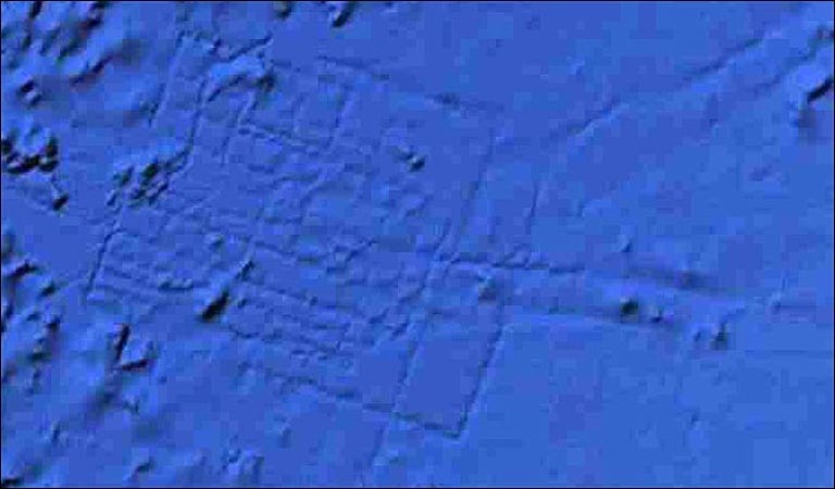
From what it sounds like, a British aeronautical engineer was playing around with the new Google Earth 5.0, which includes undersea data, and noticed something funny off the coast of Africa, about 600 miles west of the Canary Islands, that resembled a pattern of a street grid. According to the United Kingdom's Press Association, the pattern of streets equated to an area the size of Wales.

In case you've had more important things to read about for the past few thousand years, Atlantis was a legendary island city first mentioned by Plato, allegedly a hard-core naval power located somewhere near North Africa that disappeared when it sank into the ocean. Guess global warming was a problem back then, too.

Anyway, most people think that Plato made it up, kind of like how those guys in Georgia made up the story about shooting Bigfoot, but others just won't stop believin'.

So this guy is trawling the ocean floor with Google Earth--ah, if only we had that kind of free time on our hands--and was quick to announce his discovery. It looks like The Telegraph reported the story first, adding that the exact coordinates are 31 15'15.53N, 24 15'30.53W.

Recently, Google's mapping products have revealed everything from a creepy dude walking around with a sniper rifle to what appear to be U.S. drones in Pakistan.

But when it comes to Atlantis, Google totally had to rain on everyone's parade. "It's true that many amazing discoveries have been made in Google Earth, including a pristine forest in Mozambique that is home to previously unknown species and the remains of an ancient Roman villa," a statement from Google read. "In this case, however, what users are seeing is an artifact of the data collection process. Bathymetric (or sea floor terrain) data is often collected from boats using sonar to take measurements of the sea floor. The lines reflect the path of the boat as it gathers the data."

I smell a cover-up!

In other news, that pendulum map on last week's "Lost" was totally awesome.

Caroline McCarthy, a CNET News staff writer, is a downtown Manhattanite happily addicted to social-media tools and restaurant blogs. Her pre-CNET resume includes interning at an IT security firm and brewing cappuccinos. E-mail Caroline.
Recent posts from The Social
Going rogue? Palin bans gadgets, reporters from speech
Facebook: We're going after scammy ads, too
Offerpal Media mess gets stickier
After onstage spat, Offerpal replaces CEO
Beatles catalog comes to USB
MySpace changes terms of use to combat app scams
Twitter translates into Spanish
Spotify: A love song
Add a Comment (Log in or register) Showing 1 of 6 pages (199 Comments)
by mrcjacobs February 20, 2009 8:07 AM PST
I'm organizing an expedition right now to go and lay claim for salvage rights!
Reply to this comment
by keonih February 22, 2009 10:54 AM PST
COOL THAT MEANS U WON'T BE GABBING HERE...BYE....
by cactus2jack August 29, 2009 8:16 PM PDT
think ive found another "thing"... no way it could be caused by earth quakes r anything, BTW totally new to this, but I can tell that this isnt "mother nature" made.

these lines are straight, but they dont stay in the same "continues" line, and if u look close they make squares, I dont know myself, thats why im posting, to see what you think . dont know how to use this, so will try to give co-ordinates >> 14o 24`17.99"N 55o 41`09.52"W elev -5382 m , let me know what yas think.
by Kev_Orng February 20, 2009 8:30 AM PST
Grid-like city street patterns are a fairly modern invention. I would expect Atlantis to be a little more curvy
Reply to this comment
by martin1212 February 20, 2009 11:13 AM PST
Actually you couldn't be more wrong. Grid layouts have been around for thousands of years, Roman, Greek and Chinese civilizations all used them as well as several even earlier cultures.
by StretcherBearerBand February 20, 2009 11:49 AM PST
In the Description given by plato, Atlantis was a City oc Concentric Cicles, Canals, and bridges in a Circular pattern. In The song Atlantis, Donovan Sings and talks.....But seriously, Atlantian Legend tells of a city of concentric circles.
And If the lines represented are the work of sonorous relctions and the path that the boat took, My Question....Is this the guy who drove the Valdez oil Tanker drunk? Nah it resembles an early civilization city layout, But the Size of Wales? thas maore like a Principality size Pretty big comparitivly speeking to a typical City of the ancient world. Atlantis Probably not, early Huge City-State? Maybe, Underwater Scientology UFO PROOF DEFINitve PROOF?... Sorry I guess Ray-Bans And Tighty whiteys IS right...Christ L. Ron Hubbards coming back with a trunkload of more poorly wriiten crap Sci-Fi Manuscripts! It truly is the end of days...******* big Brother....
by DustyWusty February 20, 2009 1:04 PM PST
No concentric circles = No Atlantis. NEXT QUESTION.
by bluemudkipz February 20, 2009 10:10 PM PST
I agree with Stretcher and Dusty. (If you two prefer to be referred to differently, sorry about that.) Atlantis' city plan is made of concentric circles. Close but no cigar, Google Earth. Actually, not even that close.
by Lerianis February 22, 2009 2:10 AM PST
And Plato couldn't be wrong? I mean, he admittedly, in his own words, had never been to Atlantis himself...... so it's probable that he could have gotten the 'concentric streets' thing wrong. I mean.... NO city uses concentric streets that I know of... something doesn't sound right there.
by keonih February 22, 2009 9:58 AM PST
Its a city, not Pamela Anderson, think city streets not swimsuit edition ok?
by trd1282 February 22, 2009 5:17 PM PST
"Grid-like city street patterns are a fairly modern invention."

Harappa, 3600 B.C.
by bigdingaling February 24, 2009 8:49 PM PST
We have Centric circles in our Nations capital city 'Lerianis' - do a google maps search for "Canberra, Australia"

Stupid town planners thought it was a good idea, turns out it makes it difficult to navigate. Plus it looks ugly unless u live in space. If Atlantis is ever found....we may discover the builders were just like Canberra town planners -stupid.
by ppgreat February 20, 2009 8:38 AM PST
Actually it's the burial ground for all those mythical 'purchased' Vista disks.
Reply to this comment
by Eljaygee February 21, 2009 7:11 AM PST
First of all, none of you have ever seen or been to Atlantis. For that matter, neither did Plato. His information was based on hearsay for who knows how long in the past and from how many people.
All any one has to do is to look at the city layouts of Sumer, Egypt, Greece and other ancient cultures and you will see that rectangular grid patterns existed before the more creative circle designs.
It is clear that the Powers That Be want to close the case on this in order to monopolize the search and findings in the hope of finding 'Alien" artifacts just like they have in Iraq and when they went to the Moon in the 60s and 70,s.
You people have to look with better eyes.
by ralfthedog February 21, 2009 11:19 AM PST
Eljaygee , No I have not been to Atlantis. I have seen the TV show on the SCIFI channel. This city looks nothing like the one on TV. I have also been to Atlanta. It looks nothing like that either. It could be Tulsa.
by Angmarr February 21, 2009 9:02 PM PST
along with the Mac Airs
by OMGMagicCow February 22, 2009 8:39 AM PST
I agree with Ejaygee.
And ralf do you know how dumb you sound 'i saw atlantis on tv'?
None of us have seen Ataltnis. And jsut because Plato says how it looks like, ven thouh he hasnt actually been there, you think you know all about it.
Then again, ATlantis is legend. The definition of legend is a made up story.
by keonih February 22, 2009 10:54 AM PST
ADOLESCENT
by chrisfrary February 25, 2009 7:14 AM PST
OMGMagiccow... That was clearly a joke...thanks for taking it seriously though
by ebmace February 20, 2009 8:38 AM PST
Would aqueducts or canals be straight (grid-like) or curvy?
Reply to this comment
by Kev_Orng February 20, 2009 9:05 AM PST
Not sure, how did they do it on Mars?
by hi_im_bob February 20, 2009 8:41 AM PST
If you can keep a secret I will reluctantly share with you, that is a new Google Data Center.
Reply to this comment
by caroline.mccarthy February 20, 2009 9:48 AM PST
Ha! Comment of the day award!
by blusky08 February 20, 2009 3:08 PM PST
It could be an underwater base--either human or extraterrestrial.
There are many reports of USOs (Unidentified Submersible Objects). Presumably, "they" would need bases.
by appletoys February 21, 2009 5:23 PM PST
ahhh! I'm telling on you.
by dnomyar34 February 22, 2009 11:46 PM PST
Instant Truth: On earth, at 31 15'15.53N, 24 15'30.53W, Google will be using fuel cells to cool its data center, thus the need for large amounts of water and an organized array of roads to transport those hard drives that keep buning out.
by rangrand February 24, 2009 8:34 PM PST
Actually, you aren't too far off with that guess. In September Google applied for a patent for off-shore water powered data centers. The issue with this patent is that if the data centers are off-shore, depending on distance - they aren't governable by any countries laws . Meaning all those "Rules of the Web" that tell crawlers what content they may or may not crawl and how content may be used, stored and retained become unenforceable.

http://appft1.uspto.gov/netacgi/nph-Parser?Sect1=PTO1&Sect2=HITOFF&d=PG01&p=1&u=%2Fnetahtml%2FPTO%2Fsrchnum.html&r=1&f=G&l=50&s1=%2220080209234%22.PGNR.&OS=DN/20080209234&RS=DN/20080209234

It would be interesting if it were Atlantis though. I would much prefer that be Atlantis than to know Google is planning to build data centers that the government can't control. Google's great but who really wants all content on their computer and web correspondence (and I mean ALL) to be in the hands of the destroyers of "privacy".
by fusillijerry February 20, 2009 8:41 AM PST
yeah, descriptions of Atlantis were concentric circles with harbors and bridges between them. Could be something, but Atlantis it's not. Sorry. Read more Plato if you don't believe me.
Reply to this comment
by nephari February 20, 2009 9:35 AM PST
Spoilsport!
by NASAcrew February 20, 2009 8:46 AM PST
Google could make this claim if they did not have a cloud of doubt over their operation. However, since they currently use Gov. tools to gather data, and publish the data given to them, I have reservations about their claims.

It would be great if a 3rd party Scientific Group without US ties could take a "Look under the Covers". This seems to be a natural fit for Francine Cousteau, President of the Cousteau Society to undertake, in great honor of her late husband!
Reply to this comment
by tangogaucho1 February 23, 2009 12:03 PM PST
Better yet, send the Pink Panther and Mr. Clouseau!!!
by professionaladventurer February 20, 2009 8:49 AM PST
This place is not a secret, several have visited in the last 10 years.
Reply to this comment
by thelemurking February 20, 2009 8:57 AM PST
You won't find Atlantis on Google Earth... it's in the Pegasus galaxy. Sheesh, it only took Daniel Jackson like 6 or 7 years to figure it out.
Reply to this comment
by CorwinB February 20, 2009 2:03 PM PST
Not years, Seasons! Seasons!
by MadLyb February 22, 2009 4:45 AM PST
Awesome!
by muzakaz February 20, 2009 8:59 AM PST
That was a fun, cheap thrill. Darn it!
Reply to this comment
by Kev_Orng February 20, 2009 9:15 AM PST
Actually, you'd probably enjoy Googlesightseeing.com

From funny stuff to interesting stuff. People passed out on their own lawn, ship graveyards. The animals in Africa are awesome (google used hi-res photos from a plane to get in closer than the satellite image).
And they've been at it for a while now, so the archives are full of good stuff
Reply to this comment
by egghead1619 February 20, 2009 9:19 AM PST
It kind of looks like a ship from the Vogon Constructor Fleet that misjudged the distance and slammed into the ocean floor leaving behind its footprint. This probably alerted the dolphins who appealed to the galactic government for a temporary hold on construction of an interstellar bypass through our orbit. The dolphins have since been trying to convince us to contest this construction, yet unfortunately we have misunderstood their intentions.
Reply to this comment
by emodkate February 20, 2009 10:19 AM PST
<snigger> dolphins - not as smart as they think.
by StretcherBearerBand February 20, 2009 11:53 AM PST
Curse the Volgon s, and their Damn Poetry! Now I sit here rocking back and forth all day, until THE STAFF comes aroung with my sleepytime meds.....
by Dalkorian February 20, 2009 12:37 PM PST
The dolphins ain't the dumb ones here emodkate.
by Inconnux February 20, 2009 9:37 AM PST
If you look carefully you can read 'so long and thanks for all the fish'...
Reply to this comment
by Dylan_Wisor February 20, 2009 3:03 PM PST
So sad it had to come to this.
by Sporlo February 20, 2009 9:13 PM PST
I love those books (just had to say it)
by XenonofArcticus February 20, 2009 9:54 AM PST
Crikey, people are idiots.

Bathymetry (underwater terrain) is created from satellite/gravitometer data, as well as sonar traces and sounding from research ships. These areas seen here are where a research ship did a grid-search pattern while taking soundings. This (sparse) data was then merged into the surrounding very-low-detail data, which makes it stand out and look artificial. The only artificial bit is that it is high-detail data inset in a grid-pattern caused by the ship that acquired the data.

You can probably find many instances of odd patterns of sounding-tracks all over the world.

It's not frickin' Atlantis.
Reply to this comment
by StretcherBearerBand February 20, 2009 12:10 PM PST
I Insist that you take a Bath, then measure it using sattalite and bats sonor, then meticulously mere this data to find the atificial patten that lurks in the syntax of pseudo-intellectuals that don't understand that nTHERE IS NO POINT TO ARGUING whether or not it is Atlantis...It's more likely that it has to do with fracture and fissures( those thing you get on your bum from sitting and playing warcraft or some other nonsense all day long in you Spock t-shirt) Underwater landsslides, sublimation of plates, It's near mozabique right? Probably close to a faultline since well, This thing called PLATE tectonics, happens where plate boudries meet. Underwater crap can be Huge **** shook loose, and roll around in wierd ways, the seafloors, kinda slimy in the tropic, subtropic regions, and water helps move stuff around, by the moons gravitation( TIDE PULL) effects on the ear in the equatorial regions, causing it to to swell, and elongate, kind of like a half-flattened dough ball, and contract, Neat, Earth Sciences, and Working in the Astrogeological/Cartographical Divison of the USGS as a janitor payed off!
Who Cares if it's Atlantis, there examples of 20 different societies pre Plato, that are plausible canidates, It's a METAPHOR.....You Don't care, Battle star Glactica is ending soon, So Who's the Silo or grain loft o whatever the hell ever...Do they still have tweeky on ther BEEDEEBEEDEE
by Dalkorian February 20, 2009 12:40 PM PST
You're both way out to lunch, as is Caroline. It's a marking from the grey aliens telling other aliens that they have already been here. Kind of like when we paint a large X on a building after we've searched it for survivors after a disaster.
by Lazarus522 February 20, 2009 1:37 PM PST
People may be idiots, but at least most don't start their comment with "Crikey".
by annuit_coeptis February 22, 2009 4:59 PM PST
XenonofArcticus is not only square-on with the explanation but I'll direct y'all's attention to another area with sparsely scattered bathymetric data: the Arctic seas. Reason: Kinda hard to ping the bottom of the ocean when your path is blocked by an ice cap.

Unless you happen to be underneath that ice.

Take a look, particularly east of the Svalbards (north of Norway, with its award-winning coast). Some nice precise sounding points zig-zagging around what is otherwise a map of educated guesswork. I should know. I helped leave some of those "trails".

Sincerely,
Slartibartfast's Right-Hand Man
by dnomyar34 February 22, 2009 11:50 PM PST
Why in all Googles images of earth, only the state of Oregon, USA is 100% High Res.?
by JBSimmons February 28, 2009 6:31 AM PST
Well, as a PBS Special put it, Oregon is the #1 home to meth labs. Perhaps that's why the DEA probably wanted it in HighRes first... So I guess they twisted Google's arm to do it...
by inachu February 20, 2009 10:06 AM PST
So Google took a image of sonic sonar sounds..........

yeah right.
Reply to this comment
by egghead1619 February 20, 2009 11:28 AM PST
How intelligent you are. The images you think Google took, are in fact computer generated topographic maps based on the sonar data received from ships and aircraft. If these were true images, then you would not see the bottom of the ocean, rather the surface and maybe 10m down.
by Bob_299 February 20, 2009 10:18 AM PST
The Atlantis legend is surrounded by too much goofiness. There appears to be a compelling archeological case for identifying the Mediterranean volcanic island of Santorini with Atlantis, leaving an Atlantis that was much like (and culturally related to) Bronze Age Crete. Otherwise, one is left with castles in the sky.
Reply to this comment
by Kev_Orng February 20, 2009 10:38 AM PST
So it's not made up of interconnected space-age round buildings arranged in stacks, protected by a glass dome and inhabited by mer-people driving water-cars like an underwater George Jetson?

Drat.
by Hunnter2k3 February 20, 2009 10:26 AM PST
It is obviously an underwater city that the governments of the world are building to house all their smartest people.
Reply to this comment
by Dalkorian February 20, 2009 12:42 PM PST
No, I get it - it's where Saddam hid his WMD's!

LOL - ;-)
by Earth16 February 21, 2009 8:34 AM PST
Then it won't be very large.
by viper396 February 23, 2009 3:18 PM PST
Thankfully you'll never be there.
by georgegumpert February 20, 2009 10:36 AM PST
Looks like it shows up in Google Earth 4.3 as well...ah well.
Reply to this comment
by chrisaroz February 20, 2009 10:40 AM PST
The pendulum was cool, but it didn't look like the map moved. If that's the case, wouldn't the pendulum ALWAYS mark the spot in the middle? Doesn't seem very practical.

Oh, and Atlantis yada yada yada Stargate yada yada yada.
Reply to this comment
by someguynamedbob February 20, 2009 10:51 AM PST
ITS THE LOST CITY OF ATLANTA
Reply to this comment
by ikramerica--2008 February 20, 2009 9:05 PM PST
And the magician. And Jane Fonda was there too...
by MadLyb February 24, 2009 4:26 PM PST
It's not just a Delta Hub!
Showing 1 of 6 pages (199 Comments)
advertisement

FAQ: Buying the right Windows 7 upgrade

Readers still have lots of questions on just which version of the software they need to buy in order to upgrade their PC. CNET News tries to offer some answers.

N.Y. lawsuit details Intel's 'largesse' toward Dell

Attorney General Andrew Cuomo's federal antitrust case filed Wednesday alleges a longstanding symbiotic relationship between Intel and Dell.

About The Social

CNET News' Caroline McCarthy is a downtown Manhattanite who believes that, despite popular opinion, the Web can actually help your social life. She's happily addicted to fun social-media tools from Twitter to Yelp to Facebook, sends an inordinate number of text messages, and has a tendency to waste time at the office reading restaurant blogs. Here, she explores all facets of the Web's gregarious side, as well as the unique tech culture in her home city of New York. (Don't call it Silicon Alley.)

Add this feed to your online news reader

The Social topics

advertisement
advertisement

Inside CNET News

Scroll Left Scroll Right